
健行筆記-讓登山安全又有趣
Contains ads
4.2star
7.06K reviews
100K+
Downloads

Everyone
info

About this app
Welcome to explore the beauty of the mountains and forests with your hiking notes! Remember that climbing is not about walking and traveling. Check the weather and route, prepare the proper equipment, download the offline map and set off, Let’s GO!
The main purpose of developing this APP is to allow mountain friends to explore and record the forest in a safe and interesting way. The main functions are: import trajectories, record trajectories, make a variety of offline maps for offline use, participate in online themed hiking activities, and inquire about hiking routes across Taiwan, Theme routes, routes near your location, and outdoor activities, and you can share every personal hiking achievement.
To
Exploring and importing the trail of hiking trails
To discover the hiking and hiking routes of various mountain friends, you can directly search and import the trajectories uploaded by others in the GPX trajectory database of the hiking notes website, or GPX opened from other places, or find the desired route trajectory in the route database of the hiking notes website . In addition, five kinds of maps can be converted directly online at any time to correspond to the track, which is very convenient!
To
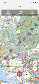
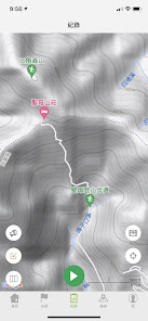
Record the trajectory
You can record personal hiking trails, mark check-in points and take photos along the way, share your own hiking achievements, and display your own and imported trajectories on the map at the same time to ensure that you are walking on the correct trajectory. In addition, each track information you recorded, such as time, mileage, total rise, and total decline, will be counted in your personal achievements for sharing, and can be displayed with the "Monthly Hand-painted Plants Unique to Taiwan".
To
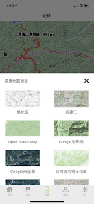
・ Make offline maps for use
You can use Lu Maps, Jingjian Third Edition Maps, Google Topographic Maps, OSM Maps, and Japanese Topographic Maps to make offline maps for offline use without internet signals. The map range can be directly downloaded as a track coverage range or a customized range.
To
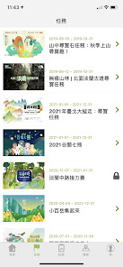
Participate in online hiking activities
All kinds of online themed hiking activities, use exclusive designed themed photo frames and check-in points, and collect unique online hiking badges to share your hiking achievements.
・ Cloud storage and sharing
After recording your hiking trail, you can upload it directly to the hiking notes GPX trajectory database, save it and share it, and help others in planning your route.
The most complete database of hiking routes and activities
You can view the most complete database of hiking and hiking routes and outdoor activities in Taiwan on the hiking notes website. It is a good helper for hiking and hiking.
To
Features:
Record the total mileage and total time of your hiking trail
・ Record personal hiking trail records, check in, punctuate and take photos along the way, and match photos or share achievements with the unique species of Taiwan every month
・ Photos taken along the way when recording the track can be kept in the APP and in the mobile phone
・ Traces recorded by others can be directly imported from the GPX database, route database, external import, mobile phone memory GPX from the hiking notes website
You can import other people's records and record your own track at the same time
・ Five types of offline maps can be made
・ View information on outdoor activities in Taiwan
Check out the hiking notes and information about hiking and hiking routes in Taiwan
・ Participate in various online themed walks, exclusive themed photo frames and check-in icons
Precautions
Although mobile phone GPS can increase the safety of outdoor activities, it is only for auxiliary use. Mountaineering should be handled according to the actual situation to avoid danger and at your own risk. Do not check your mobile phone when you are on the move. When you need to check your mobile phone, you should stop at a safe place.
The main purpose of developing this APP is to allow mountain friends to explore and record the forest in a safe and interesting way. The main functions are: import trajectories, record trajectories, make a variety of offline maps for offline use, participate in online themed hiking activities, and inquire about hiking routes across Taiwan, Theme routes, routes near your location, and outdoor activities, and you can share every personal hiking achievement.
To
Exploring and importing the trail of hiking trails
To discover the hiking and hiking routes of various mountain friends, you can directly search and import the trajectories uploaded by others in the GPX trajectory database of the hiking notes website, or GPX opened from other places, or find the desired route trajectory in the route database of the hiking notes website . In addition, five kinds of maps can be converted directly online at any time to correspond to the track, which is very convenient!
To
Record the trajectory
You can record personal hiking trails, mark check-in points and take photos along the way, share your own hiking achievements, and display your own and imported trajectories on the map at the same time to ensure that you are walking on the correct trajectory. In addition, each track information you recorded, such as time, mileage, total rise, and total decline, will be counted in your personal achievements for sharing, and can be displayed with the "Monthly Hand-painted Plants Unique to Taiwan".
To
・ Make offline maps for use
You can use Lu Maps, Jingjian Third Edition Maps, Google Topographic Maps, OSM Maps, and Japanese Topographic Maps to make offline maps for offline use without internet signals. The map range can be directly downloaded as a track coverage range or a customized range.
To
Participate in online hiking activities
All kinds of online themed hiking activities, use exclusive designed themed photo frames and check-in points, and collect unique online hiking badges to share your hiking achievements.
・ Cloud storage and sharing
After recording your hiking trail, you can upload it directly to the hiking notes GPX trajectory database, save it and share it, and help others in planning your route.
The most complete database of hiking routes and activities
You can view the most complete database of hiking and hiking routes and outdoor activities in Taiwan on the hiking notes website. It is a good helper for hiking and hiking.
To
Features:
Record the total mileage and total time of your hiking trail
・ Record personal hiking trail records, check in, punctuate and take photos along the way, and match photos or share achievements with the unique species of Taiwan every month
・ Photos taken along the way when recording the track can be kept in the APP and in the mobile phone
・ Traces recorded by others can be directly imported from the GPX database, route database, external import, mobile phone memory GPX from the hiking notes website
You can import other people's records and record your own track at the same time
・ Five types of offline maps can be made
・ View information on outdoor activities in Taiwan
Check out the hiking notes and information about hiking and hiking routes in Taiwan
・ Participate in various online themed walks, exclusive themed photo frames and check-in icons
Precautions
Although mobile phone GPS can increase the safety of outdoor activities, it is only for auxiliary use. Mountaineering should be handled according to the actual situation to avoid danger and at your own risk. Do not check your mobile phone when you are on the move. When you need to check your mobile phone, you should stop at a safe place.
Updated on
Safety starts with understanding how developers collect and share your data. Data privacy and security practices may vary based on your use, region, and age. The developer provided this information and may update it over time.

No data shared with third parties
Learn more about how developers declare sharing

This app may collect these data types
Personal info and App info and performance

Data is encrypted in transit

You can request that data be deleted
Ratings and reviews
4.2
7.02K reviews

gerald
- Flag inappropriate
December 13, 2024
lots of trails available for country of taiwan! sadly i cant fully participate in the grand trail event because my country is not selectable in the app. this is preventing me from finishing with my app registration.
H2U Club
December 16, 2024
您好,若您APP使用上仍有問題,煩請將相關資訊 Email 至客服信箱 hikingnote@gmail.com,客服專員會協助處理排除問題。

Shelby Holland
- Flag inappropriate
March 16, 2023
I tried to download this app because it was recommended to me, but it won't even let me open the app even though I gave it all the permissions it asked for. A hiking app shouldn't need my contacts information in my opinion. This app seems like a scam since the first thing it asks you to do is to allow the app full permission to all your data.....maybe if they change their permission settings I would consider redownloading.....
3 people found this review helpful
H2U Club
September 25, 2023
您好,謝謝您的建議回饋, 我們會再進行評估調整,山友們的評價與回饋是健行團隊最大的動力了,謝謝。

Neil Barrett
- Flag inappropriate
- Show review history
January 18, 2024
I cannot open the app on my Google pixel 6. It worked before. I gave permission to use my location and camera but it still will not open.
1 person found this review helpful
H2U Club
January 18, 2024
你好,若持續遇到相同情況,煩請將相關資訊 Email 至客服信箱 hikingnote@gmail.com,客服專員會協助處理排除問題。
1. 問題說明或提供截圖。
2. 會員編號:可於 App畫面「我」>「帳號設定」中查詢。
3. 手機型號/系統版本:例如,SAMSUNG Galaxy S23 /android 13。
4. 健行APP版本。
What’s new
1. 技術優化升級現有功能
2. 世壯運尋寶任務
3. 修正推播問題
2. 世壯運尋寶任務
3. 修正推播問題
App support
About the developer
H2U Corporation
hsuan.hsu@h2u.io
231633台湾新北市新店區
北新路三段213號15樓
+886 978 482 223


